

191 The Collection of John Elliot Lawford | Part 2: Online Auction (lot 95-432)
Admiralty Hydrographic Office 'Entrance to Auckland Harbour'
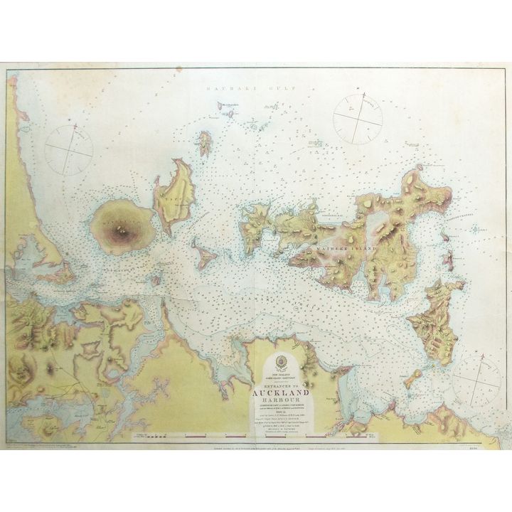
205
Admiralty Hydrographic Office 'Entrance to Auckland Harbour'
Est.
$500 - $800
Sold
$2,000
Admiralty Hydrographic Office 'New Zealand, North Isle...'
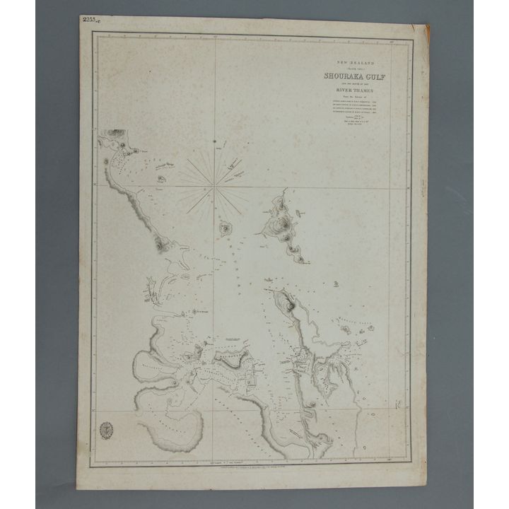
206
Admiralty Hydrographic Office 'New Zealand, North Isle...'
Est.
$300 - $500
Sold
$950
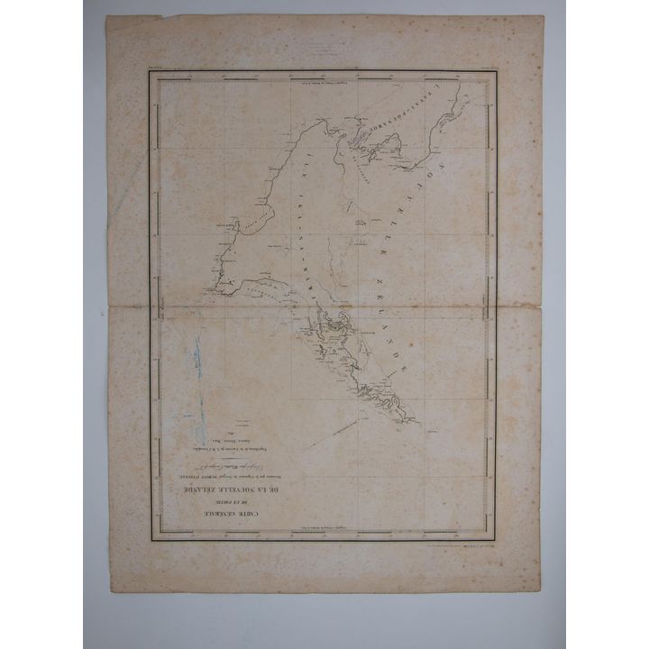
Admiralty Hydrographic Office 'New Zealand. The Northern Coast from Hokianga.'
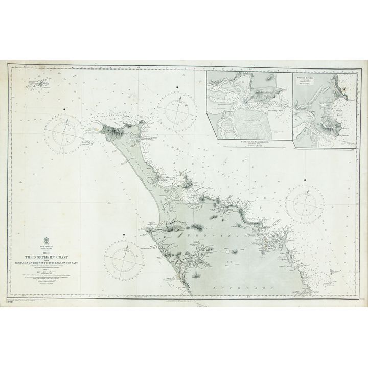
207
Admiralty Hydrographic Office 'New Zealand. The Northern Coast from Hokianga.'
Est.
$600 - $800
Sold
$300

Jacques Nicolas Bellin 'Essai d’une carte réduite contenant les parties connues du globe terrestre'
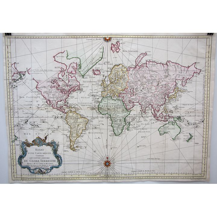
209
Jacques Nicolas Bellin 'Essai d’une carte réduite contenant les parties connues du globe terrestre'
Est.
$300 - $500
Sold
$500
Bowen Thomas [2x] 'The World including the late Discoveries'
![Bowen Thomas [2x] 'The World including the late Discoveries'](https://images4-cdn.auctionmobility.com/is3/auctionmobility-static4/UTxt-4-17QZ8N/4-BXM49X/191-210.jpg?width=720&height=720&resizeinbox=true)
210
Bowen Thomas [2x] 'The World including the late Discoveries'
Est.
$200 - $400
Sold
$325
James Cook 'Kaart van Nieuw Zuid Wales of de Oostlijke Kust van Nieuw Holland'
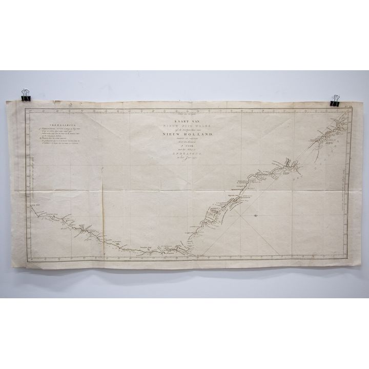
211
James Cook 'Kaart van Nieuw Zuid Wales of de Oostlijke Kust van Nieuw Holland'
Starting Bid: $140
Est.
$300 - $400
Ended
Captain M.L.I. Duperry 'Carte De La Baie des Iles (Bay of Islands) (Nouvelle Zealande)'
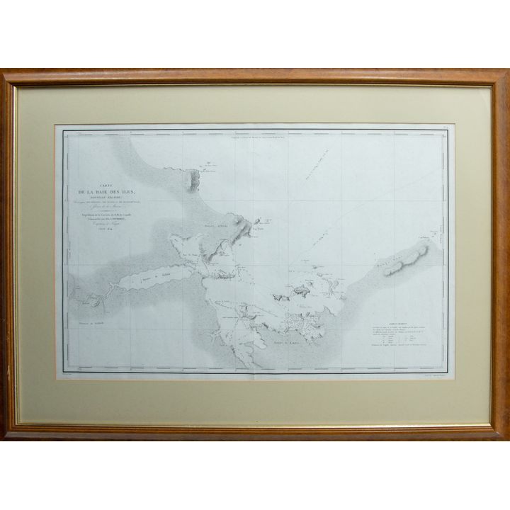
212
Captain M.L.I. Duperry 'Carte De La Baie des Iles (Bay of Islands) (Nouvelle Zealande)'
Est.
$600 - $800
Sold
$750
Reiner & Joshua Ottens 'Magnum Mare del Zur cum Insula California'
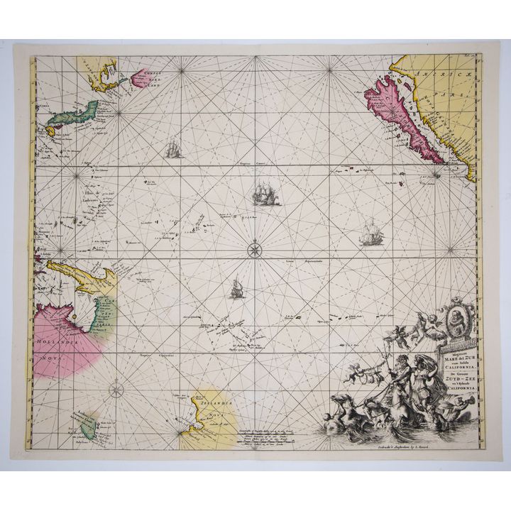
213
Reiner & Joshua Ottens 'Magnum Mare del Zur cum Insula California'
Est.
$1,000 - $1,200
Sold
$800
Charles Heaphy 'Plan of Fort St, Auckland'
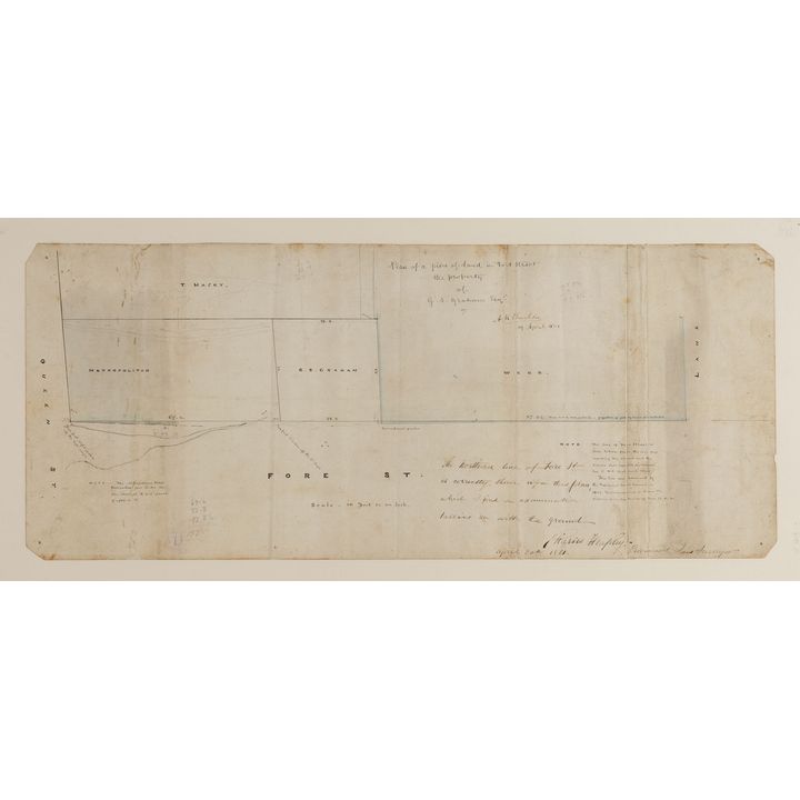
214
Charles Heaphy 'Plan of Fort St, Auckland'
Est.
$1,500 - $2,500
Sold
$1,050
James Imray & Sons 'Western Pacific Chart No.1'
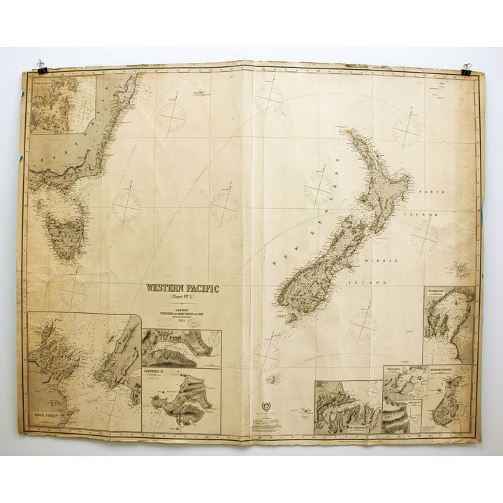
215
James Imray & Sons 'Western Pacific Chart No.1'
Est.
$800 - $1,200
Sold
$850

Edward Stanford 'Map of the Province of Canterbury, New Zealand'
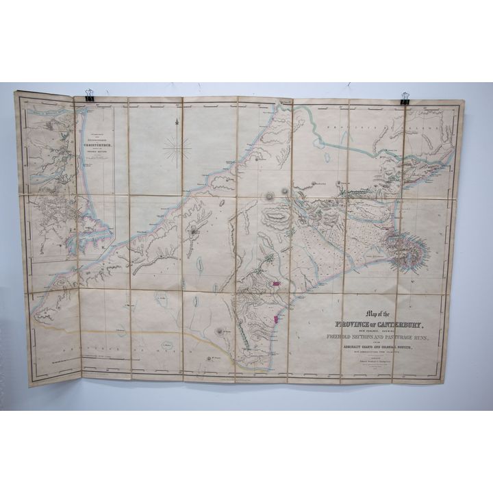
217
Edward Stanford 'Map of the Province of Canterbury, New Zealand'
Est.
$500 - $700
Sold
$1,100
John Varty 'Map of Waikato & Coromandel Peninsula'
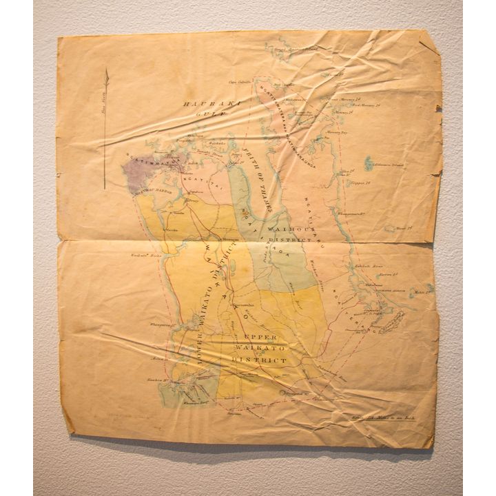
218
John Varty 'Map of Waikato & Coromandel Peninsula'
Est.
$400 - $600
Sold
$600
James Wyld 'This Chart of New Zealand'
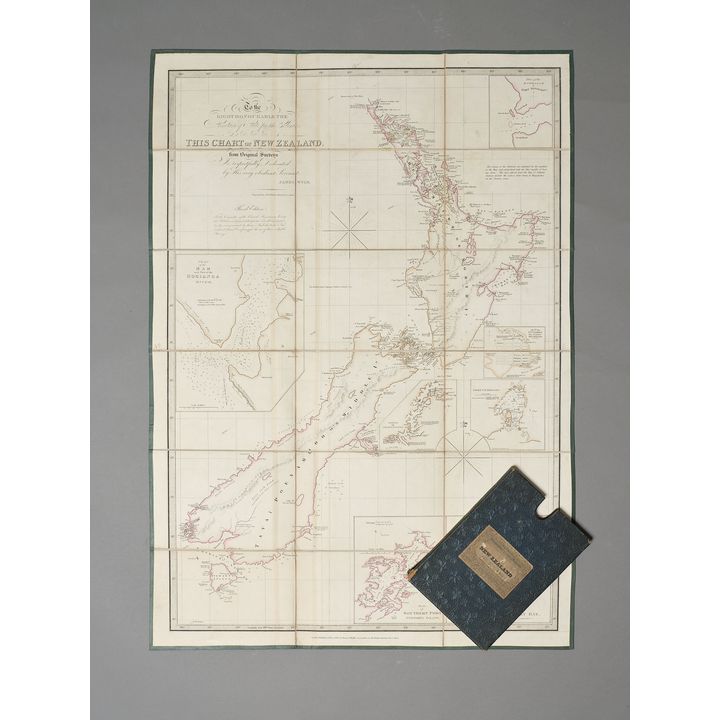
219
James Wyld 'This Chart of New Zealand'
Est.
$800 - $1,200
Sold
$1,300
Antonio Zatta 'La Nuova Zelanda...'
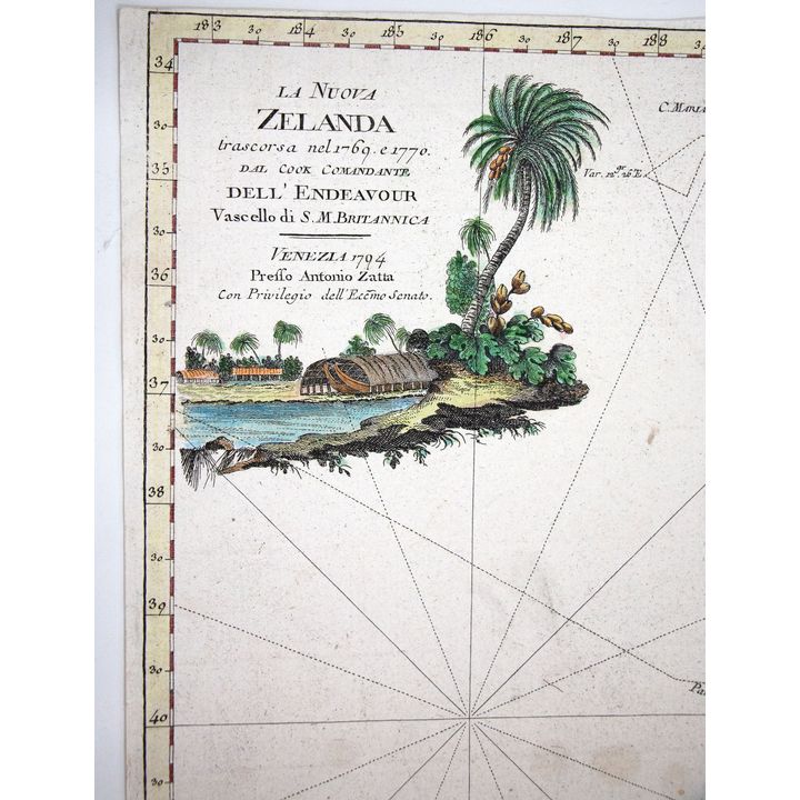
220
Antonio Zatta 'La Nuova Zelanda...'
Est.
$600 - $800
Sold
$700
196 Rare Books including The John Mowbray Collection
MALING, PETER BROMLEY - Early Charts of New Zealand. 1542 - 1851.
57
MALING, PETER BROMLEY - Early Charts of New Zealand. 1542 - 1851.
Est.
$200 - $300
Sold
$300
MALING, PETER BROMLEY - Historic Charts and Maps of New Zealand 1642 - 1875.
58
MALING, PETER BROMLEY - Historic Charts and Maps of New Zealand 1642 - 1875.
Est.
$150 - $250
Sold
$110
BARROW, JOHN [1796] - A General Chart, on Mercator's Projection,
![BARROW, JOHN [1796] - A General Chart, on Mercator's Projection,](https://images4-cdn.auctionmobility.com/is3/auctionmobility-static4/wdzU-4-17QZ8N/4-DC6CLS/196-230.jpg?width=720&height=720&resizeinbox=true)
230
BARROW, JOHN [1796] - A General Chart, on Mercator's Projection,
Est.
$300 - $500
Sold
$190
BONNE, RIGOBERT - Carte De La Nouvelle Zeelande
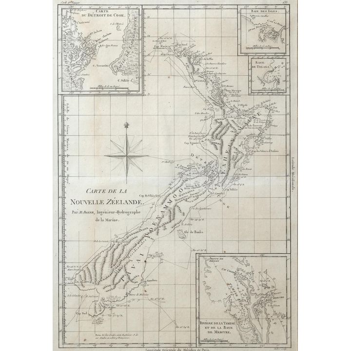
231
BONNE, RIGOBERT - Carte De La Nouvelle Zeelande
Est.
$500 - $700
Sold
$425
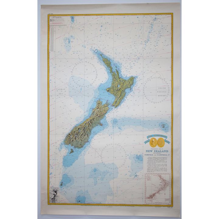
Chart of New Zealand - Cook Bicentenary Commemorative Chart of New Zealand including Norfolk and Campbell Is,
232
Chart of New Zealand - Cook Bicentenary Commemorative Chart of New Zealand including Norfolk and Campbell Is,
Est.
$80 - $100
Sold
$40
de SAINSON, LOUIS AUGUSTE - Village de Korora-Reka. [Nouvelle Zelande]
![de SAINSON, LOUIS AUGUSTE - Village de Korora-Reka. [Nouvelle Zelande]](https://images4-cdn.auctionmobility.com/is3/auctionmobility-static4/K1zg-4-17QZ8N/4-DC6CLY/196-233.jpg?width=720&height=720&resizeinbox=true)
233
de SAINSON, LOUIS AUGUSTE - Village de Korora-Reka. [Nouvelle Zelande]
Est.
$300 - $350
Sold
$150
DE SAINSON. D’URVILLE [3 lithographs] - Vue De Kahouwera. Village fortife a la baie des iles. Nouvelle Zelande
![DE SAINSON. D’URVILLE [3 lithographs] - Vue De Kahouwera. Village fortife a la baie des iles. Nouvelle Zelande](https://images4-cdn.auctionmobility.com/is3/auctionmobility-static4/U1mD-4-17QZ8N/4-DC6CM0/196-234.jpg?width=720&height=720&resizeinbox=true)
234
DE SAINSON. D’URVILLE [3 lithographs] - Vue De Kahouwera. Village fortife a la baie des iles. Nouvelle Zelande
Est.
$300 - $500
Sold
$500
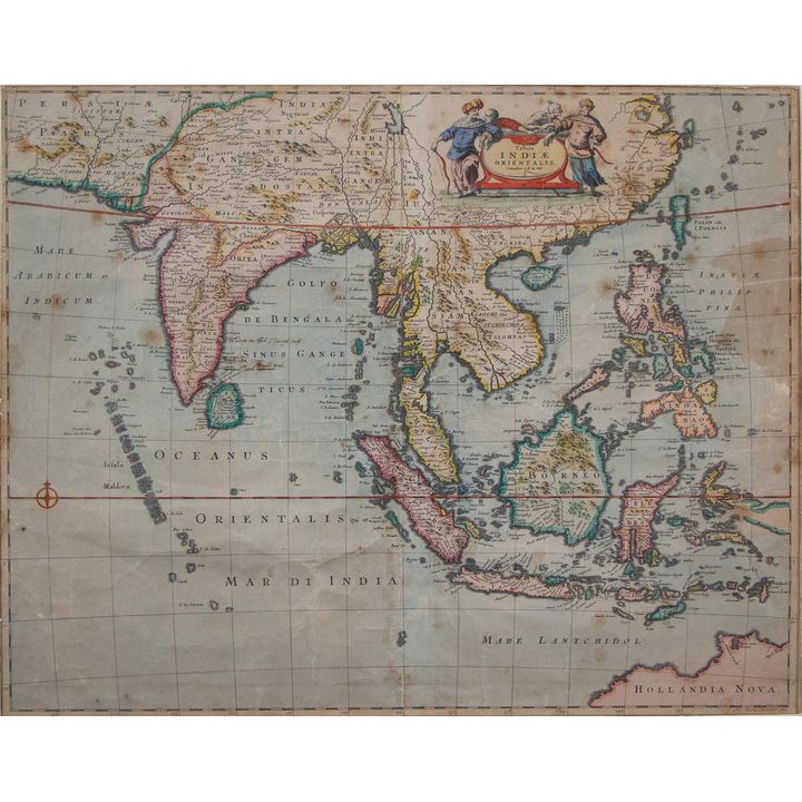
De WITT, FREDERICK - Tabula Indiae Orientalis
235
De WITT, FREDERICK - Tabula Indiae Orientalis
Est.
$300 - $500
Sold
$750
DOWER, JOHN [2 maps] - E Weller Lithogr. [London], Weekly Dispatch Atlas, [1870?].
![DOWER, JOHN [2 maps] - E Weller Lithogr. [London], Weekly Dispatch Atlas, [1870?].](https://images4-cdn.auctionmobility.com/is3/auctionmobility-static4/58Hr-4-17QZ8N/4-DC6CM4/196-236.jpg?width=720&height=720&resizeinbox=true)
236
DOWER, JOHN [2 maps] - E Weller Lithogr. [London], Weekly Dispatch Atlas, [1870?].
Est.
$200 - $400
Sold
$325
DUMONT, D'URVILLE - Carte De La Partie De La Nouvelle Zelande Reconnue par Le Capitaine De Fregate Dumont
237
DUMONT, D'URVILLE - Carte De La Partie De La Nouvelle Zelande Reconnue par Le Capitaine De Fregate Dumont
Est.
$600 - $800
Sold
$300
HACQ, J.M. [engraver] - Carte de l'Archipel des Iles Viti:
![HACQ, J.M. [engraver] - Carte de l'Archipel des Iles Viti:](https://images4-cdn.auctionmobility.com/is3/auctionmobility-static4/PW2R-4-17QZ8N/4-DC6CM8/196-238.jpg?width=720&height=720&resizeinbox=true)
238
HACQ, J.M. [engraver] - Carte de l'Archipel des Iles Viti:
Starting Bid: $300
Est.
$600 - $800
Ended
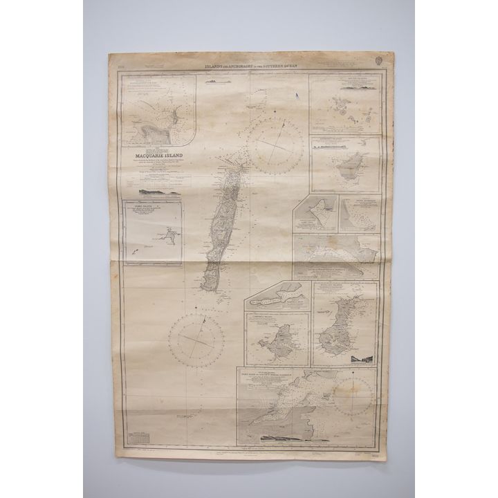
HYDROGRAPHIC MAP - ISLAND AND ANCHORAGES IN THE SOUTHERN OCEAN
239
HYDROGRAPHIC MAP - ISLAND AND ANCHORAGES IN THE SOUTHERN OCEAN
Est.
$600 - $800
Sold
$200
HYDROGRAPHIC MAP - TAURANGA - Surveyed by B. Drury [and others] 1852.
![HYDROGRAPHIC MAP - TAURANGA - Surveyed by B. Drury [and others] 1852.](https://images4-cdn.auctionmobility.com/is3/auctionmobility-static4/8Mp8-4-17QZ8N/4-DC6CMC/196-240.jpg?width=720&height=720&resizeinbox=true)
240
HYDROGRAPHIC MAP - TAURANGA - Surveyed by B. Drury [and others] 1852.
Est.
$600 - $800
Sold
$400
JAMIESON, ALEXANDER - A Celestial Atlas, comprising a Systematic Display of the Heavens in a Series of Thirty Maps

241
JAMIESON, ALEXANDER - A Celestial Atlas, comprising a Systematic Display of the Heavens in a Series of Thirty Maps
Est.
$600 - $1,000
Sold
$950
MAP - NEW ZEALAND - Its Chief Industries 1892.
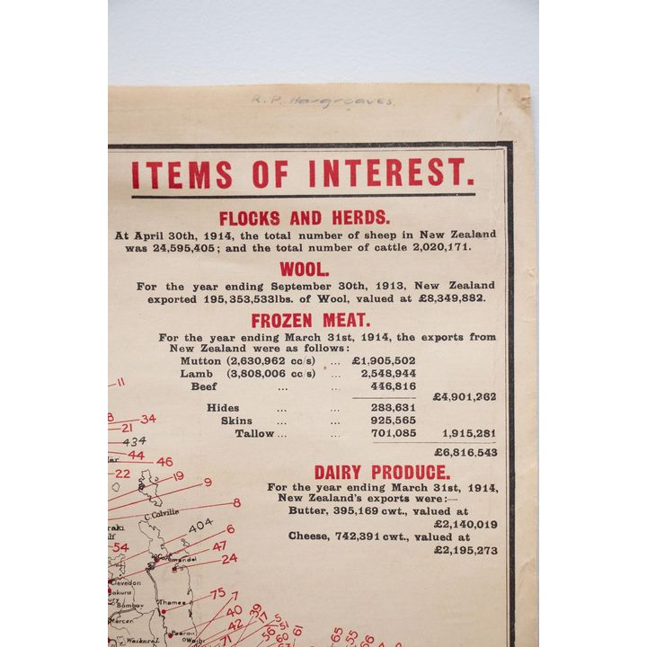
242
MAP - NEW ZEALAND - Its Chief Industries 1892.
Est.
$200 - $300
Sold
$1,050
MAP - NORTH ISLAND - Railways of the North Island of New Zealand 1896.

243
MAP - NORTH ISLAND - Railways of the North Island of New Zealand 1896.
Est.
$100 - $200
Sold
$220
MAPS - LAND TENURE - North and South Island Land Tenure Maps 1902-03
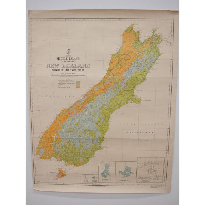
244
MAPS - LAND TENURE - North and South Island Land Tenure Maps 1902-03
Est.
$300 - $500
Sold
$600
PLAN OF EAST AUCKLAND [EASTLAND] - Showing Auckland -Gisborne N.Z. Govt. Railway.
![PLAN OF EAST AUCKLAND [EASTLAND] - Showing Auckland -Gisborne N.Z. Govt. Railway.](https://images4-cdn.auctionmobility.com/is3/auctionmobility-static4/2YOv-4-17QZ8N/4-DC6CMM/196-245.jpg?width=720&height=720&resizeinbox=true)
245
PLAN OF EAST AUCKLAND [EASTLAND] - Showing Auckland -Gisborne N.Z. Govt. Railway.
Est.
$200 - $300
Sold
$130

VISSCHER, NICOLAUM [1618-1679] - Indiae Orientalis nec non Innsularum Adiacentium nova descripto
![VISSCHER, NICOLAUM [1618-1679] - Indiae Orientalis nec non Innsularum Adiacentium nova descripto](https://images4-cdn.auctionmobility.com/is3/auctionmobility-static4/V9Qg-4-17QZ8N/4-DC6CMQ/196-247.jpg?width=720&height=720&resizeinbox=true)
247
VISSCHER, NICOLAUM [1618-1679] - Indiae Orientalis nec non Innsularum Adiacentium nova descripto
Est.
$400 - $600
Sold
$1,250

